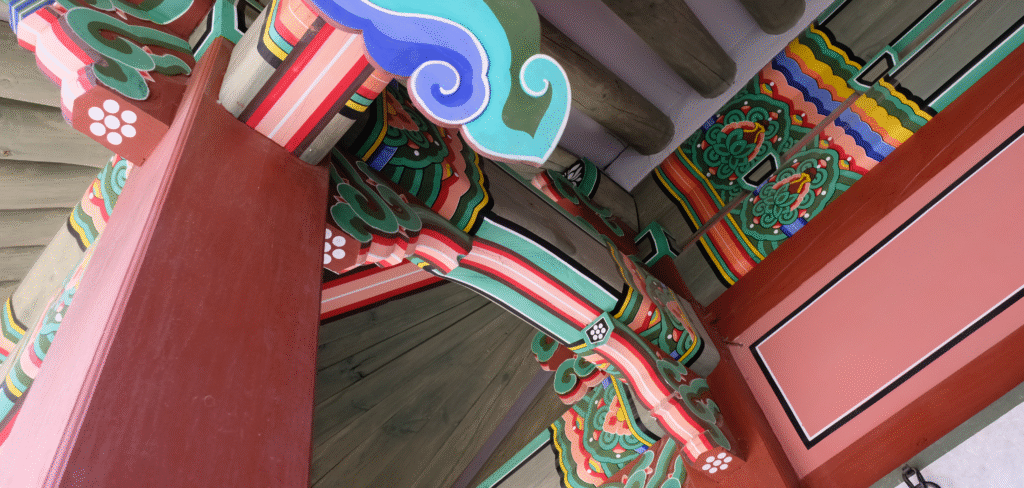
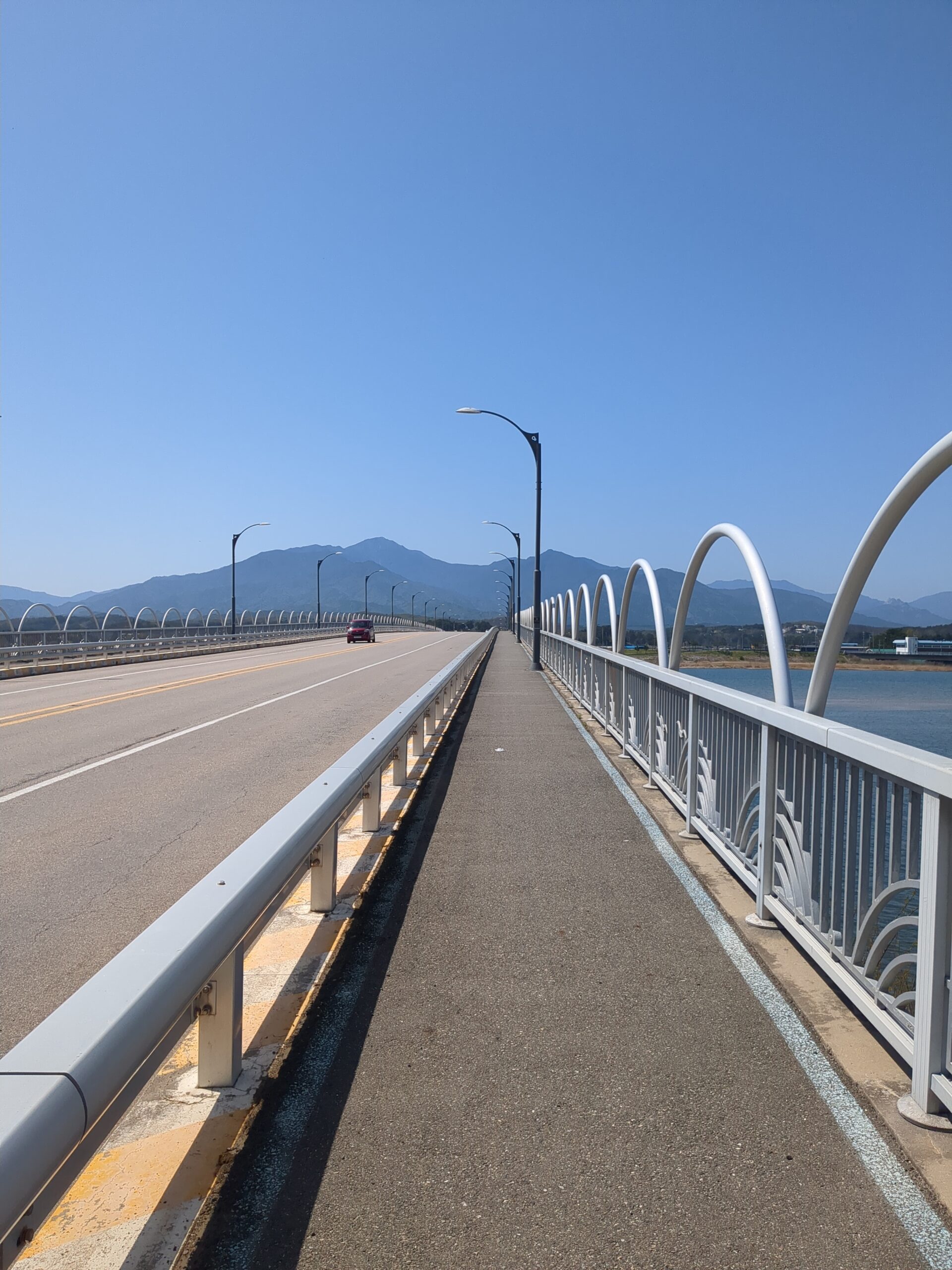
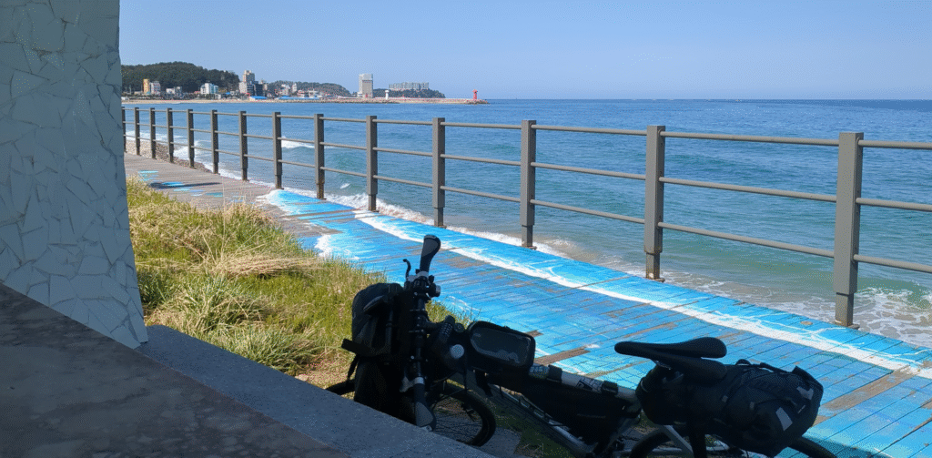
Alongside the subtropical Jeju Island, Korea’s East Coast (Donghae) is one of the most loved places to rest and enjoy the sea. Thanks to a nearby expressway, the winding coastal roads only carry local traffic, making them perfect for cycling.
Jump to transportation / accommodation / itineraries
Follow this link for general information about bicycle travel and route certification in Korea
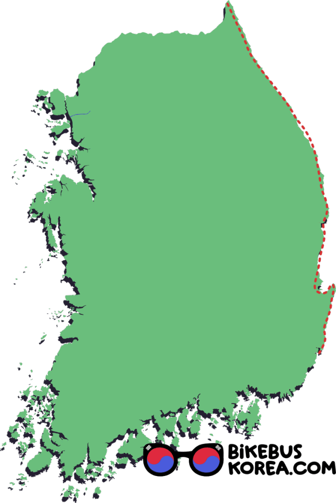
Are the East Coast Routes Connected?
Some sources, including the official bike tour certification maps, show two separate East Coast routes. These are the Gyeongbuk path from Sunrise Park to Uljin, and the Gangwon path from Imwon to the DMZ.
In reality, these paths are not only connected, but extend Southwards all the way to Ulsan Metropolitain City.
Our Cycling difficulty Rating


2/5
4/5
2/5
certification: 330km
Elevation Profile
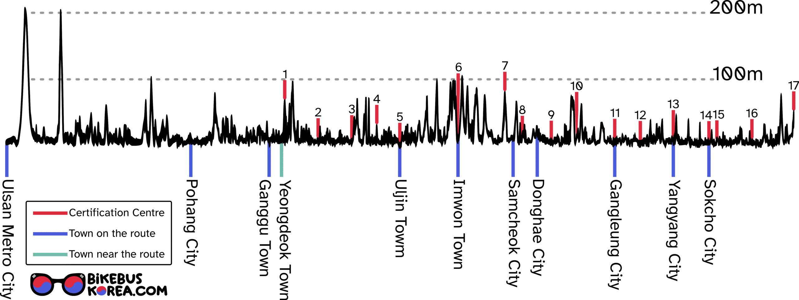
Expand for a List of Certification Centres
Certification centres are listed from South to North.
Click for Naver Map link.
North Gyeongsang (Gyeongbuk) Province
- 1. Sunrise Park
- 2. Goraebul Beach
- 3. Wolsongjeong
- 4. Mangyang Service Area
- 5. Uljin Sweet Fish Bridge
Gangwon Province
- 6. Imwon
- 7. Hanjae Park
- 8. Chuam Chotdaebawi
- 9. Mangsang Beach
- 10. Jeongdongjin
- 11. Gyeongpo Beach
- 12. Jigyeong Park
- 13. Dongho Beach
- 14. Yeonggeumjeong
- 15. Bongpo Beach
- 16. Bukcheon Railroad Bridge (Maps.me lists this as ‘Ukcheon Railroad Bridge’)
- 17. Unification Observatory
The Gyeongsang section involves regular steep ascents and descents, so it’s imperative to pack light. The route passes through plenty of villages with convenience stores, so there’s no need to carry two litres of water with you.

The Gangwon section is flatter and passes through the cities of Samcheok, Donghae, Gangleung and Sokcho. It’s worth bringing your own inkpad through Gangwon as the certification centres there are not well maintained.
Transportation to the East Coast Cycle Route
Map of Bus Terminals
Intercity buses are the best way to transport a bicycle across Korea. The map below shows bus terminals along the East Coast route.
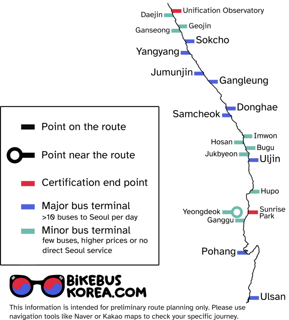
Expand for names and map links to bus terminals
Please beware that this is not an exhaustive list of bus services and that this site should not be used to check specific journeys.
We work to give an overview of available routes which you can plan in detail by yourself or by taking advantage of our support packgages.
Ulsan 울산고속버스터미널 (to Seoul Gyeongbu, East Seoul)
Ulsan 울산시외버스터미널 (to Busan Haeundae, East Seoul, Incheon airport)
Pohang 포항고속버스터미널 (to Seoul Gyeongbu)
Pohang 포항터미널 (to East Seoul, Busan, Ganggu)
Ganggu 강구버스터미널 (to Pohang 포항시외버스터미널)
Yeongdeok 영덕터미널 (to Seoul Gyeongbu, East Seoul, Busan Dongbu)
Hupo 후포터미널 (to East Seoul)
Uljin 울진종합버스터미널 (to East Seoul, some services to Busan Dongbu)
Jukbyeon 죽변시외버스정류장 (to East Seoul, some services to Pohang)
Bugu 부구터미널 (to East Seoul, one daily service to Busan Dongbu)
Hosan 호산버스정류장 (to East Seoul, limited service to Busan)
Imwon 임원버스정류소 (to East Seoul)
Samcheok 삼척고속버스터미널 (to Seoul Gyeongbu, East Seoul)
Donghae 동해시종합버스터미널 (to Seoul Gyeongbu, East Seoul, Busan)
Gangleung 강릉시외버스터미널 (to Seoul Gyeongbu, East Seoul, Pohang, Wonju)
Jumunjin 주문진시외버스종합터미널 (to East Seoul, Seoul Nambu)
Yangyang 양양종합여객터미널 (East Seoul, Seoul Gyeongbu)
Sokcho 속초고속버스터미널 (to Seoul Gyeongbu, East Seoul, Incheon, Cheonan)
Sokcho 속초시외버스터미널 (to East Seoul, Busan Dongbu, most major cities plus many local Gangwon Province services)
Ganseong 간성터미널 (to East Seoul)
Geojin 거진시외버스터미널 (to East Seoul, occasional Sokcho, Busan and Pohang services)
Daejin 대진시외버스터미널 (to East Seoul)
If you’re aiming for the bike tour certification, you might want to begin and end your route as close to the certification centres as possible. The trouble is that neither of the end points are in urban areas, so they are not well served by intercity buses.
Buses to Sunrise Park Certification Centre (southernmost stamp)
There are three options for bus terminals close to Sunrise park, the southernmost certification centre. These are Yeongdeok, Ganggu and Pohang.
Yeongdeok is a small town with buses arriving from Seoul Gyeongbu Terminal (about 3 per day) and East Seoul (about 7 per day). It is 11km inland from Sunrise park, and the road from Yeongdeok to the coast is steep and relatively busy.
Ganggu is a local terminal, directly on the coast, 11km south of Sunrise Park. However, there are no services from Seoul or Busan – you will have to transfer in a nearby city like Pohang.
For many, waiting for a second bus in Pohang isn’t worth it – like Ganggu, Pohang is directly on the coast, and only 50km from Sunrise Park. It is a major city with buses almost twice hourly from Seoul Gyeongbu.
Buses to Unification Observatory Certification Centre (northernmost stamp)
Daejin Terminal, 4km South of the final certification centre, has about 8 buses per day to and from East Seoul. The closest main terminal is Sokcho, which is very well connected.
Expand for an idea of bus times to and from Daejin
This information is not updated regularly. It is intended for preliminary route planning only.
From East Seoul to Daejin
06:49, 08:20, 09:30, 11:20, 13:35, 16:09, 17:30, 19:15
From Daejin to East Seoul
07:10, 08:00, 08:40, 10:30, 11:30, 13:30, 15:10, 16:30, 18:00
Journey times are between 3h and 3h30.
At the time of writing (January 2026) tickets cost 25,600KRW.
Disclaimer: this information is intended for preliminary route planning only and may not be accurate.
Sokcho Intercity (속초시외버스터미널) also has services to Chuncheon, which is connected to Seoul via the Bukhangang (North Han River) bike path.
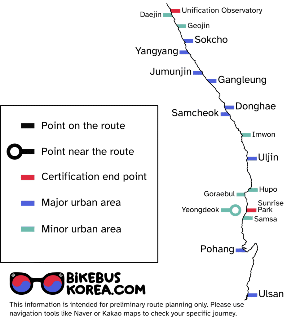
Accommodation
The popularity of the East Coast means that accommodation is available along most of this route. However, it can be expensive (100-250,000won per night) in more rural areas where only pensions (seaview holiday properties) are available.
For budget friendly accommodation, you should stick to hotels and motels, which you are more likely to find in urban areas.
The map below shows urban areas where you may find accommodation. See below for daily itinerary suggestions.
Urban areas on the East Coast
Daily Itinerary Suggestions
Given the flexibility of end points and various ways you might be arriving on the East Coast, it’s difficult to make specific recommendations. However, we see four likely starting points:
South to North: wake up in Pohang / wake up in Yeongdeok / cycling from Yeongdeok Bus Terminal
North to South: bus from East Seoul to Daejin
links are to points in areas with accommodation but not to specific hotels or motels
Variant 1: Wake up in Pohang
Pohang is the closest major city to Sunrise Park Certification Centre, and it is directly on the coast.
Cross-country Cruise: 40-60km per day
Enjoy the scenery, stop for coffee, don’t break a sweat (weather permitting). Includes stops in smaller towns with more limited, usually less modern accommodation options.
Day 1: Pohang to Samsa 50km
Day 2: Samsa to Goraebul (Byeonggok-ri) 40km
Day 3: Goraebul to Uljin Town 60km
Day 4: Uljin to Imwon 40km
Day 5: Imwon to Samcheok City 40km
Day 6: Samcheok to Gangleung City 60km
Day 7: Gangleung to Yangyang Town 50km
Day 8: Yangyang to Geojin Town 55km
Day 9: Geojin to Unification Observatory to Geojin loop 25km (plenty of time for the observatory) then take a bus from Geojin (minor bus terminal) OR
Day 10: Geojin to Sokcho Bus Terminal 40km
Sightseeing Sprinter: 60-100km per day
Learn about Korean history, explore less touristic cities; cycling to experience the landscape in between. Aiming for cities means this route has the best options for accommodation.
Day 1: Pohang to Goraebul (Byeonggok-ri) 80km
Day 2: Goraebul to Uljin Town 60km
Day 3: Uljin to Samcheok City 80km
Day 4: Samcheok to Jumunjin 75km or Gangleung City 60km
Day 5: Gangleung to Sokcho 65km
Day 6: Sokcho – Unification Observatory (50km) – Geojin (+11km) – this should leave time to spend at the observatory OR
Day 6: Sokcho – Unification Observatory – Sokcho loop (100km) without going up to see over the DMZ.
Tour de Corée: 80-120km per day
For athletic cyclists stopping only to eat and sleep, and who can manage a few big climbs in one day
Day 1: Pohang to Goraebul (Byeonggok-ri) 80km
Day 2: Goraebul to Imwon 90km
Day 3: Imwon to Gangleung City 95km
Day 4: Gangleung to Geojin Town 100km
Day 5: Geojin – Unification Observatory – Geojin (loop) 25km (plenty of time for the observatory) then take a bus from Geojin (minor bus terminal) OR continue to Sokcho terminal (+50km, maybe no time for the observatory)
Variant 2: Wake up in Yeongdeok
Yeongdeok is the closest terminal to Sunrise Park with regular services to Seoul.
It is closer to Sunrise Park than Pohang, but is not directly on the cycle-friendly coastal road and requires a climb on a relatively busy road to get out of the town.
Cross-country Cruise: 40-60km per day
Enjoy the scenery, stop for coffee, don’t break a sweat (weather permitting). Includes stops in smaller towns with more limited, usually less modern accommodation options.
Day 1: Yeongdeok to Hupo Town 45km
Day 2: Hupo to Uljin Town 50km
Day 3: Uljin to Imwon 40km
Day 4: Imwon to Samcheok City 40km
Day 5: Samcheok to Gangleung City 60km
Day 6: Gangleung to Yangyang Town 50km
Day 7: Yangyang to Geojin Town 55km
Day 8: Geojin to Unification Observatory to Geojin loop 25km (plenty of time for the observatory) then take a bus from Geojin (minor bus terminal) OR
Day 9: Geojin to Sokcho Bus Terminal 40km
Sightseeing Sprinter: 60-100km per day
Learn about Korean history, explore less touristic cities; cycling to experience the landscape in between. Aiming for cities means this route has the best options for accommodation.
Day 1: Yeongdeok to Uljin Town 90km
Day 2: Uljin to Samcheok City 80km
Day 3: Samcheok to Jumunjin 75km or Gangleung City 60km
Day 4: Gangleung to Sokcho 65km
Day 5: Sokcho – Unification Observatory (50km) – Geojin (+11km) – this should leave time to spend at the observatory OR
Day 6: Sokcho – Unification Observatory – Sokcho loop (100km) without going up to see over the DMZ.
Tour de Corée: 80-120km per day
For athletic cyclists stopping only to eat and sleep, and who can manage a few big climbs in one day
Day 1: Yeongdeok to Uljin Town 90km
Day 2: Uljin to Samcheok City 80km
Day 3: Samcheok to Jumunjin 75km
Day 4: Jumunjin to Geojin Town 90km
Day 5: Geojin – Unification Observatory – Geojin (loop) 25km (plenty of time for the observatory) then take a bus from Geojin (minor bus terminal) OR continue to Sokcho terminal (+50km, maybe no time for the observatory)
Variant 3: Bus to Yeongdeok and begin cycling
Cross-country Cruise: 40-60km per day
Enjoy the scenery, stop for coffee, don’t break a sweat (weather permitting). Includes stops in smaller towns with more limited, usually less modern accommodation options.
Day 1: Bus to Yeongdeok, cycle to Goraebul (Byeonggok-ri) 35km
Day 2: Goraebul to Uljin Town 60km
Day 3: Uljin to Imwon 40km
Day 4: Imwon to Samcheok City 40km
Day 5: Samcheok to Gangleung City 60km
Day 6: Gangleung to Yangyang Town 50km
Day 7: Yangyang to Geojin Town 55km
Day 8: Geojin to Unification Observatory to Geojin loop 25km (plenty of time for the observatory) then take a bus from Geojin (minor bus terminal) OR
Day 9: Geojin to Sokcho Bus Terminal 40km
Sightseeing Sprinter: 60-100km per day
Learn about Korean history, explore less touristic cities; cycling to experience the landscape in between. Aiming for cities means this route has the best options for accommodation.
Day 1: Bus to Yeongdeok, cycle to Goraebul (Byeonggok-ri) 35km
Day 2: Goraebul to Uljin Town 60km
Day 3: Uljin to Samcheok City 80km
Day 4: Samcheok to Jumunjin 75km or Gangleung City 60km
Day 5: Gangleung to Sokcho 65km
Day 6: Sokcho – Unification Observatory (50km) – Geojin (+11km) – this should leave time to spend at the observatory OR
Day 6: Sokcho – Unification Observatory – Sokcho loop (100km) without going up to see over the DMZ.
Tour de Corée: 80-120km per day
For athletic cyclists stopping only to eat and sleep, and who can manage a few big climbs in one day
Day 1: Bus to Yeongdeok, cycle to Goraebul (Byeonggok-ri) 35km
Day 2: Goraebul to Imwon 90km
Day 3: Imwon to Gangleung City 95km
Day 4: Gangleung to Geojin Town 100km
Day 5: Geojin – Unification Observatory – Geojin (loop) 25km (plenty of time for the observatory) then take a bus from Geojin (minor bus terminal) OR continue to Sokcho terminal (+50km, maybe no time for the observatory)
Variant 4: Bus from East Seoul to Daejin
Daejin is the closest bus terminal to Unification Observatory Certification Centre and has services from East Seoul Bus Terminal. Click here to jump to the schedule.
Cross-country Cruise: 40-60km per day
Enjoy the scenery, stop for coffee, don’t break a sweat (weather permitting). Includes stops in smaller towns with more limited, usually less modern accommodation options.
Day 1: Bus to Daejin, visit the Unification Observatory (3.5km from the terminal) – cycle to Geojin (11km)
Day 2: Geojin to Yangyang Town 55km
Day 3: Yangyang to Gangleung City 60km
Day 4: Gangleung to Samcheok City 60km
Day 5: Samcheok to Imwon Town 40km
Day 6: Imwon to Uljin Town 40km
Day 7: Uljin to Goraebul (Byeonggok-ri) 60km
Day 8: Goraebul to Yeongdeok (35km) and take a bus OR
Day 8: Goraebul to Samsa 40km
Day 9: Samsa to Pohang City 50km
Sightseeing Sprinter: 60-100km per day
Learn about Korean history, explore less touristic cities; cycling to experience the landscape in between. Aiming for cities means this route has the best options for accommodation.
Day 1: Bus to Daejin, visit the Unification Observatory (3.5km from the terminal) – cycle to Geojin (11km)
Day 2: Geojin to Yangyang Town 55km
Day 3: Yangyang to Gangleung City 60km
Day 4: Gangleung to Samcheok City 60km
Day 5: Samcheok to Uljin Town 80km
Day 6: Uljin to Goraebul (Byeonggok-ri) 60km
Day 7: Goraebul to Yeongdeok (35km) and take a bus OR
Day 8: Goraebul to Pohang City 90km
Tour de Corée: 80-120km per day
For athletic cyclists stopping only to eat and sleep, and who can manage a few big climbs in one day
Day 1: Bus to Daejin, visit the Unification Observatory, cycle to Geojin (11km) OR
Day 1: Bus to Daejin, cycle North 4km for the Unification Observatory stamp (skipping the DMZ observatory itself) then cycle south to Sokcho City (50km)
Day 2: Sokcho to Donghae City 110km
Day 3: Donghae to Uljin Town 90km
Day 4: Uljin to Yeongdeok (95km) ready to take a bus the following day OR
Day 4: Uljin to Samsa 90km
Day 5: Samsa to Pohang City 50km
click to see our overview of national cycling routes
Still need help?
Get in touch for personal advice and support here.